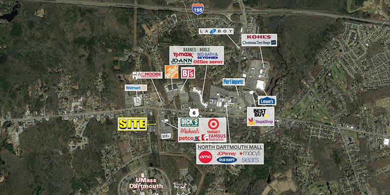
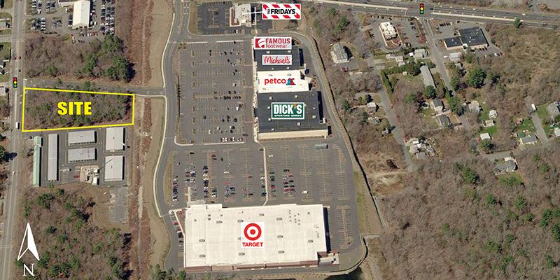
Commercial Land
479 State Road Dartmouth, MA 02747
Details & Description
Call for Pricing
    Dartmouth Commons• Total project size of 250,000 SF• 127,000 SF Target• 2 acres available
    Listing Agents
    Brian Roache

    O: 617-239-3638
    broache@atlanticretail.com
    While we strive to provide the most accurate information, all listing information, and demographic data, is provided by third-parties. As such, MyEListing will not be responsible for the accuracy of the information. It is strongly recommended that you verify all information with the listing agent, and any relevant agencies, prior to making any decisions.

    479 State Road

    Dartmouth, MA 02747

    Listing ID: 210735
    • 479 State Road Dartmouth, MA 02747 | for Sale | Photo 1
    • 479 State Road Dartmouth, MA 02747 | for Sale | Photo 2
    • 479 State Road Dartmouth, MA 02747 | for Sale | Photo 3
    479 State Road | for Sale | Thumbnail 1
    479 State Road | for Sale | Thumbnail 2
    479 State Road | for Sale | Thumbnail 3
    Building Size: --
    Lot Size: 2.000 AC
    Land Size: 87,120 SF
    Building $/SF: --
    Land $/SF: --
    Price
    Call for Pricing
    Description

    Dartmouth Commons

    • Total project size of 250,000 SF

    • 127,000 SF Target

    • 2 acres available

    Points of Interest & Demographic Radii

    Points of Interest
    Demographic Radii
    POIs provided for entertainment purposes only. Data comes from multiple data sources as well as users and agents. MyEListing makes no claims whatsoever as to the accurancy and/or completeness.
     
    Providence History of Commercial Land for Sale

    Dartmouth Area Market Trends

    Listing Demographics for 479 State Road Dartmouth, MA 02747

    All information based on the most recently available data (updated annually) and is provided in 1-mile, 3-mile, and 5-mile radii (radiuses) of the property location.

    1-Mile 3-Miles 5-Miles
    Total Population3,10826,946128,611
    Population Median Age384039
    Population by Age0-9 Yrs266 (8%)2113 (7%)14883 (11%)
    10-19 Yrs447 (14%)4019 (14%)16573 (12%)
    20-29 Yrs678 (21%)4828 (17%)21113 (16%)
    30-39 Yrs316 (10%)2785 (10%)15790 (12%)
    40-49 Yrs397 (12%)3108 (11%)15700 (12%)
    50-59 Yrs412 (13%)3495 (12%)16148 (12%)
    60-69 Yrs248 (7%)2950 (10%)13236 (10%)
    70+ Yrs345 (11%)3647 (13%)15169 (11%)
    Median HH Income$86,509$76,693$50,475
    Total Household Income< 24K176 (18%)1731 (18%)13982 (27%)
    25-49K117 (12%)1422 (15%)10907 (21%)
    50-74K105 (10%)1367 (14%)7791 (15%)
    75-99K175 (18%)1331 (14%)5808 (11%)
    100-199K353 (36%)2846 (30%)9686 (19%)
    200K+31 (3%)523 (5%)1910 (3%)
    Highest Education LevelNo Diploma325250118056
    Diploma or GED738565028334
    Some College317283213880
    Assoc. Degree11014936985
    Bachelors Degree285305011780
    Higher Degree18318486478
    Total Housing Units9959,64354,620
    --Owner-Occupied7396,42523,157
    --Renter-Occupied2162,79626,927
    Owner-Occupied Values< 100K6130752
    100-199K497774879
    200-299K21024128775
    300-399K33917694481
    400-499K1048462097
    500K+314912173
    Total Working Age Population2,64023,080105,156
    In Work Force1,71914,02763,362
    Not In Work Force9219,05341,795
    Workforce Employed1,61413,45759,684
    Workforce Unemployed1055663,660
    Civlian Workforce1,71914,02463,344
    Military Workforce0318
    Total Households9569,22150,085
    Family Households6896,37230,228
    Non-Family Households2662,84919,856
    Married Couple5334,43617,925
    Other Family1571,93712,303
    Married w/Child2321,4996,405
    Single Male w/Child211691,326
    Single Female w/Child768275,303

    Population Change Last Two Decades - Plus Projection

    2000%2010%2020%2030
    Massachusetts6,349,097+36,547,629+66,933,887+47,225,472
    Bristol County534,678+3548,285+2561,478+1567,277
    Plymouth County472,822+5494,919+5518,508+3534,464
    Rhode Island1,048,31901,052,56701,049,177+21,070,677
    Newport County85,433-382,888+1191,843-190,676

    Total Working Age Population:

    Total Households:

    Total Working Age Population:

    Total Households:

    Total Working Age Population:

    Total Households:

    No part of this information may be copied, reproduced, repurposed, or screen-captured for any commercial purpose without prior written authorization from MyEListing.

    While we strive to provide the most accurate information, all listing information, and demographic data, is provided by third-parties. As such, MyEListing will not be responsible for the accuracy of the information. It is strongly recommended that you verify all information with the listing agent, and any relevant agencies, prior to making any decisions.

    Common Questions and Answers

    How much land does the Dartmouth, MA property at 479 State Road include?
    479 State Road in Dartmouth includes 2.000 acres of land
    What kind of Land is the propery at 479 State Road?
    The property at 479 State Road Dartmouth, MA 02747 is listed as a Retail Land Land property
    What is the population within 1 mile of 479 State Road in Dartmouth?
    The population within 1 mile of 479 State Road Dartmouth, MA 02747 is 3,108 people.
    Who do I contact for questions about 479 State Road?
    You should contact the listing agent, Brian Roache, for any details regarding this commercial listing.

    Other Listings for Sale Nearby

    Address Price Sq Ft Acres
    4 Chace Road, Freetown, MA $350,000 - 2.65
    9 Harding Street, Lakeville, MA $1,200,000 - 8.5
    28 Harding St, Middleborough, MA $495,000 - 1.38
    1 Clayton Rd, Middleborough, MA $399,000 - 1.5
    112 Old Warwick Avenue, Warwick, RI $1,450,000 - 3.14
    1290 Warwick Avenue, Warwick, RI CALL - 0.44
    160 North Main Street, Plympton, MA CALL - 2.5
    30 Coronado Road, Warwick, RI $1,350,000 - 0.87
    40 Fresno Road, Warwick, RI $1,350,000 - 1.03
    307 Elm St, Warwick, RI $80,000 - 0.15

    Closest Commercial Airports

    Airport Distance (mi)
    Theodore Francis Green State Airport (PVD) 23
    General Edward Lawrence Logan International Airport (BOS) 50
    Bradley International Airport (BDL) 89