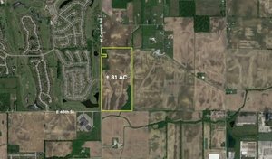
Commercial Land
9020 W 650 S Knightstown, IN 46148
Details & Description
Call for Pricing
    Interstate Site with Great access for Development. Zoned General Business-Supports Retail, Hotel-Motel, Storage, etc.
    Property Highlights
    Listing Agents
    Michael Horrigan

    O: 317-439-3452
    mhorrigan@bradleyco.com
    While we strive to provide the most accurate information, all listing information, and demographic data, is provided by third-parties. As such, MyEListing will not be responsible for the accuracy of the information. It is strongly recommended that you verify all information with the listing agent, and any relevant agencies, prior to making any decisions.

    9020 W 650 S

    Knightstown, IN 46148

    Listing ID: 259102
    9020 W 650 S Knightstown, IN 46148 | for Sale | Photo 1
    Building Size: --
    Lot Size: 7.000 AC
    Land Size: 304,920 SF
    Building $/SF: --
    Land $/SF: --
    Price
    Call for Pricing
    Property Highlights
    Adjacent to the planned Henry County Hospital Campus
    41,000 vehicles per day
    National QSR chains and travel centers at exit
    Growing and bustling corridor
    1st exit East of rapidly developing Greenfield and Hancock County
    Many possibilities with this site
    Description

    Interstate Site with Great access for Development. Zoned General Business-Supports Retail, Hotel-Motel, Storage, etc.

    Attachments & Files

    Points of Interest & Demographic Radii

    Points of Interest
    Demographic Radii
    POIs provided for entertainment purposes only. Data comes from multiple data sources as well as users and agents. MyEListing makes no claims whatsoever as to the accurancy and/or completeness.
     
    Indianapolis History of Commercial Land for Sale

    Knightstown Area Market Trends

    Listing Demographics for 9020 W 650 S Knightstown, IN 46148

    All information based on the most recently available data (updated annually) and is provided in 1-mile, 3-mile, and 5-mile radii (radiuses) of the property location.

    1-Mile 3-Miles 5-Miles
    Total Population1292,1918,417
    Population Median Age424039
    Population by Age0-9 Yrs8 (6%)213 (9%)991 (11%)
    10-19 Yrs23 (17%)410 (18%)1323 (15%)
    20-29 Yrs17 (13%)234 (10%)1097 (13%)
    30-39 Yrs8 (6%)221 (10%)944 (11%)
    40-49 Yrs18 (13%)244 (11%)911 (10%)
    50-59 Yrs25 (19%)366 (16%)1283 (15%)
    60-69 Yrs20 (15%)261 (11%)975 (11%)
    70+ Yrs11 (8%)241 (10%)893 (10%)
    Median HH Income$62,120$60,009$59,992
    Total Household Income< 24K5 (10%)154 (18%)503 (16%)
    25-49K15 (31%)183 (21%)754 (24%)
    50-74K16 (33%)237 (28%)742 (23%)
    75-99K7 (14%)120 (14%)519 (16%)
    100-199K6 (12%)135 (16%)561 (17%)
    200K+0 (0%)9 (1%)44 (1%)
    Highest Education LevelNo Diploma7122540
    Diploma or GED295662396
    Some College173081081
    Assoc. Degree10141459
    Bachelors Degree23218671
    Higher Degree387349
    Total Housing Units539363,601
    --Owner-Occupied416702,410
    --Renter-Occupied8167713
    Owner-Occupied Values< 100K122381032
    100-199K19296984
    200-299K895239
    300-399K11765
    400-499K1934
    500K+01557
    Total Working Age Population1121,7576,643
    In Work Force691,0654,204
    Not In Work Force436922,440
    Workforce Employed629784,012
    Workforce Unemployed787191
    Civlian Workforce691,0654,204
    Military Workforce000
    Total Households488373,123
    Family Households396232,264
    Non-Family Households9213859
    Married Couple304701,774
    Other Family9154490
    Married w/Child8155607
    Single Male w/Child0965
    Single Female w/Child378244

    Population Change Last Two Decades - Plus Projection

    2000%2010%2020%2030
    Indiana6,080,485+76,483,802+46,738,573+47,014,880
    Hancock County55,391+2670,002+976,353+1185,043
    Henry County48,508+249,462-348,041-545,591
    Rush County18,261-517,392-716,252-415,548

    Total Working Age Population:

    Total Households:

    Total Working Age Population:

    Total Households:

    Total Working Age Population:

    Total Households:

    No part of this information may be copied, reproduced, repurposed, or screen-captured for any commercial purpose without prior written authorization from MyEListing.

    While we strive to provide the most accurate information, all listing information, and demographic data, is provided by third-parties. As such, MyEListing will not be responsible for the accuracy of the information. It is strongly recommended that you verify all information with the listing agent, and any relevant agencies, prior to making any decisions.

    Common Questions and Answers

    How much land does the Knightstown, IN property at 9020 W 650 S include?
    9020 W 650 S in Knightstown includes 7.000 acres of land
    What kind of Land is the propery at 9020 W 650 S?
    The property at 9020 W 650 S Knightstown, IN 46148 is listed as a Mixed Use Land Land property
    What is the population within 1 mile of 9020 W 650 S in Knightstown?
    The population within 1 mile of 9020 W 650 S Knightstown, IN 46148 is 129 people.
    Who do I contact for questions about 9020 W 650 S?
    You should contact the listing agent, Michael Horrigan , for any details regarding this commercial listing.

    Closest Commercial Airports

    Airport Distance (mi)
    Indianapolis International Airport (IND) 40
    James M Cox Dayton International Airport (DAY) 71
    Cincinnati Northern Kentucky International Airport (CVG) 72