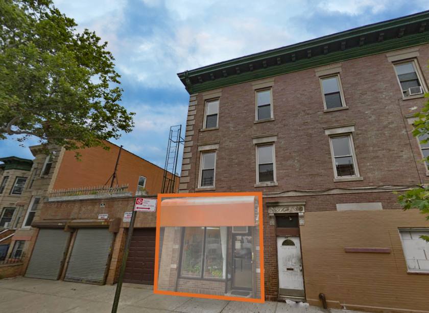
Retail Space - For Lease
451 Irving Avenue Brooklyn, NY 11237
Details & Description
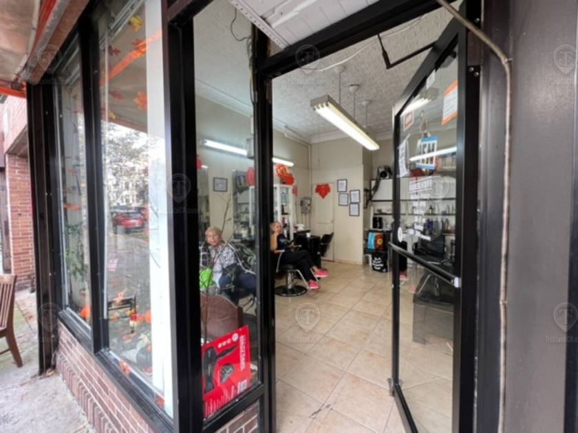
Call for Pricing
    Located in the Bushwick neighborhood of Brooklyn between Jefferson Ave & Hancock st near the Halsey St subway station.Nearest Transit: L train at Halsey St, M train at Myrtle - Wyckoff Ave, and the B26 bus line.Nearby tenants Duane Reade, Dollar Tree, Evil Twin Brewing, Dunkin', Food Bazaar, Blink Fitness, Rite Aid, Bushwick Burger Co, Capital One Bank, Popeyes, CVS, McDonald's, and more!
    Property Highlights
    Additional Photos
    Listing Agents
    Shlomi Bagdadi

    O: 718-437-6100
    info@tristatecr.com
    While we strive to provide the most accurate information, all listing information, and demographic data, is provided by third-parties. As such, MyEListing will not be responsible for the accuracy of the information. It is strongly recommended that you verify all information with the listing agent, and any relevant agencies, prior to making any decisions.

    451 Irving Avenue

    Brooklyn, NY 11237

    Retail Space for Lease

    Listing ID: 299066
    Call for Pricing
    For Lease
    • Property Type Retail for Lease : Other Retail
    • Unit Sq Ft 300
    • Service Type N/A
    • 451 Irving Avenue Brooklyn, NY 11237 | for Lease | Photo 1
    • 451 Irving Avenue Brooklyn, NY 11237 | for Lease | Photo 2
    • 451 Irving Avenue Brooklyn, NY 11237 | for Lease | Photo 3
    • 451 Irving Avenue Brooklyn, NY 11237 | for Lease | Photo 4
    • 451 Irving Avenue Brooklyn, NY 11237 | for Lease | Photo 5
    • 451 Irving Avenue Brooklyn, NY 11237 | for Lease | Photo 6
    451 Irving Avenue | for Lease | Thumbnail 1
    451 Irving Avenue | for Lease | Thumbnail 2
    451 Irving Avenue | for Lease | Thumbnail 3
    451 Irving Avenue | for Lease | Thumbnail 4
    451 Irving Avenue | for Lease | Thumbnail 5
    451 Irving Avenue | for Lease | Thumbnail 6
    Property Highlights
    • Original tin ceiling
    Description

    Located in the Bushwick neighborhood of Brooklyn between Jefferson Ave & Hancock st near the Halsey St subway station.

    Nearest Transit: L train at Halsey St, M train at Myrtle - Wyckoff Ave, and the B26 bus line.

    Nearby tenants Duane Reade, Dollar Tree, Evil Twin Brewing, Dunkin', Food Bazaar, Blink Fitness, Rite Aid, Bushwick Burger Co, Capital One Bank, Popeyes, CVS, McDonald's, and more!

    Attachments & Files

    Brooklyn Area Market Trends

    Listing Demographics for 451 Irving Avenue Brooklyn, NY 11237

    All information based on the most recently available data (updated annually) and is provided in 1-mile, 3-mile, and 5-mile radii (radiuses) of the property location.

    1-Mile 3-Miles 5-Miles
    Total Population165,1821,086,2882,903,792
    Population Median Age353638
    Population by Age0-9 Yrs17501 (10%)138862 (12%)338998 (11%)
    10-19 Yrs18364 (11%)125617 (11%)300569 (10%)
    20-29 Yrs37038 (22%)196553 (18%)481574 (16%)
    30-39 Yrs30532 (18%)184767 (17%)510453 (17%)
    40-49 Yrs19775 (11%)132654 (12%)379560 (13%)
    50-59 Yrs18440 (11%)126128 (11%)347795 (11%)
    60-69 Yrs12499 (7%)95718 (8%)280530 (9%)
    70+ Yrs11032 (6%)85987 (7%)264312 (9%)
    Median HH Income$64,917$58,429$69,534
    Total Household Income< 24K13536 (22%)105234 (26%)239800 (21%)
    25-49K9667 (16%)75069 (18%)195256 (17%)
    50-74K10426 (17%)59856 (14%)159924 (14%)
    75-99K8263 (13%)46712 (11%)132278 (11%)
    100-199K14411 (24%)85835 (21%)266400 (23%)
    200K+3382 (5%)30127 (7%)129364 (11%)
    Highest Education LevelNo Diploma23811133471333260
    Diploma or GED29428216244513292
    Some College16791109791270550
    Assoc. Degree809849991129948
    Bachelors Degree25135155676505973
    Higher Degree1062576880326877
    Total Housing Units64,692438,5441,236,177
    --Owner-Occupied11,085100,119326,379
    --Renter-Occupied48,601302,714796,642
    Owner-Occupied Values< 100K527382910594
    100-199K207221811241
    200-299K439347720433
    300-399K564726928823
    400-499K784956734441
    500K+856473759220848
    Total Working Age Population135,991869,0672,378,849
    In Work Force93,442555,6231,564,150
    Not In Work Force42,548313,444814,700
    Workforce Employed88,395513,7211,467,111
    Workforce Unemployed5,03441,61296,353
    Civlian Workforce93,428555,3331,563,464
    Military Workforce14290686
    Total Households59,686402,8331,123,021
    Family Households34,366236,983646,312
    Non-Family Households25,320165,851476,709
    Married Couple18,599126,828393,945
    Other Family15,767110,154252,367
    Married w/Child7,84354,814162,831
    Single Male w/Child1,2677,91718,431
    Single Female w/Child4,80136,68277,584

    Population Change Last Two Decades - Plus Projection

    2000%2010%2020%2030
    New York18,976,457+219,378,102+420,146,131+220,604,030
    Queens County2,229,37902,230,722+92,436,549+52,565,268
    Kings County2,465,326+22,504,700+92,738,283+52,863,996
    New York County1,537,195+31,585,873+61,688,894+21,727,631

    Total Working Age Population:

    Total Households:

    Total Working Age Population:

    Total Households:

    Total Working Age Population:

    Total Households:

    No part of this information may be copied, reproduced, repurposed, or screen-captured for any commercial purpose without prior written authorization from MyEListing.

    While we strive to provide the most accurate information, all listing information, and demographic data, is provided by third-parties. As such, MyEListing will not be responsible for the accuracy of the information. It is strongly recommended that you verify all information with the listing agent, and any relevant agencies, prior to making any decisions.

    Listing Location & Map Views
    Other Retail Space Listings for Lease Nearby
    Address Price Sq Ft Acres
    451 Irving Avenue, Brooklyn, NY CALL 1,100 -
    679 Knickerbocker Avenue, Brooklyn, NY CALL 1,300 -
    513 Wilson Avenue, Brooklyn, NY CALL 550 -
    448 Wilson Avenue, Brooklyn, NY CALL 350 -
    329 Irving Avenue, Brooklyn, NY CALL 400 -
    1519 Decatur Street, Queens, NY CALL 420-4,647 -
    1519 Decatur Street, Queens, NY CALL 2,948-10,889 -
    1519 Decatur Street, Queens, NY CALL 1,491-8,083 -
    56-40 Myrtle Avenue, Queens, NY CALL 3,600 -
    279 Saint Nicholas Avenue, Brooklyn, NY CALL 500 -
    Closest Commercial Airports
    Airport Distance (mi)
    La Guardia Airport (LGA) 6
    John F Kennedy International Airport (JFK) 8
    Newark Liberty International Airport (EWR) 14
    Listing Agent
    More listings from Shlomi Bagdadi
    Featured Local Vendors
    • SUPPORT OUR FREE PLATFORM •
    The below vendors allow us to provide our platform at no cost. Please consider their services when needed.
    • SE0/SEM •
    Foreignerds logo
    Organic & Social Media Marketing
    • Dumpster Service •
    Dumpster Rental Dogs  logo
    Dumpsters delivered to your door!
    • Port-a-Potty •
    Porta Potty Dogs  logo
    Sometimes you just need to go....
    • Commercial Surveying •
    • Digital Media Services •
    • Appraisal Company •
    AmeriMac logo
    Proper valuation for buying or selling
    • Environmental Studies •

    Share
    Other property types near Brooklyn, NY